top of page


Hiking Trips
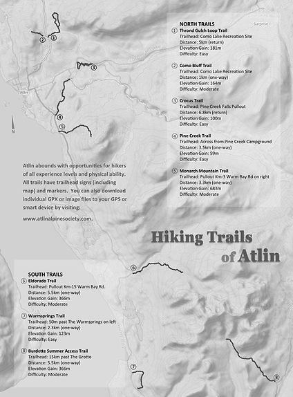
Atlin Hiking Trails
1.Thrond Gultch Loop
The Thrond Gulch Loop is a multi-use trail made up of several roads and trails. The eastern portion follows a road and quad track through beautiful open pine forests while the western part is a mix of single track and quad trail through slightly more hilly and varied forests of pine, popular and spruce.
2. Como Bluff Trail
The trail head is at the Como Lake rec site and follows a ridge up to the peak north of pillman hill. This trail over looks Como Lake and offers a great view down the north end of Atlin lake and Mount Minto at the top. The trail also doubles as an access trail to one of Atlin's busiest rock climbing crags. The trail is suitable for all fitness levels and is close to town.
3.Crocus Trail
The Crocus Trail features a ridge line walk with sweeping views of Atlin Lake and the surrounding mountains. This is a great hike for an afternoon activity as it does not have a large elevation change but still delivers beautiful views.
4. Pine Creek Trail
The Pine Creek Trail follows Pine Creek from the PineCreek Campground to the hydrolelectric generating station. The trail is Atlin’s only riparian trail and was originally established in the 1980s as a recreation opportunity for visitors.
5.Monarch Mountain Trail
The Monarch Mountain Trail is easily Atlin’s most popular trail. It features a moderate
hike up the shoulder of the mountain and features incredible 360 degree views of the Atlin area.
6.Eldorado Alpine Access Trail
This historical trail that dates back to the gold rush is a well used trail that leads the user up into the alpine of the Eldorado valley, it originated as an access trail to a dam built for mining over 120 years ago. The trailhead is on the south side of Mckee Creek bridge.
7.Warm Springs Trail
The Warm springs Trail follows the remnants of an old wood road dating back to the 1930s.
The Warm springs is a micro-ecology different from the rest of the Atlin area and features plants that don’t grow anywhere else. The trail terminates with a sweeping view of Llewellyn Glacier and Atlin Provincial Park.
8. Burdette Summer Trail
The trail head is 17 km past the grotto following a forestry road. It is the primary access route to the Burdette cabin. The trail takes the user through diverse eco systems which helps create an appreciation of the beauty the Atlin area has to offer. The trail generally follows simple terrain but does have moderate sections that requires some coordination.


Click here to download the GPX tracks to all the trails.
bottom of page